|![[Search]](http://talks.cam.ac.uk/images/search.gif?1209136071) |
|![[A-Z Index]](http://talks.cam.ac.uk/images/az.gif?1209136071) |
|![[Contact]](http://talks.cam.ac.uk/images/contact.gif?1209136071)
| COOKIES: By using this website you agree that we can place Google Analytics Cookies on your device for performance monitoring. | ![[Talks.cam]](http://talks.cam.ac.uk/images/talkslogosmall.gif?1209136071) |
University of Cambridge > Talks.cam > British Antarctic Survey - Director's Choice > Antarctic ice flow: what can we learn by combining models and measurements?
Antarctic ice flow: what can we learn by combining models and measurements?Add to your list(s) Download to your calendar using vCal
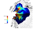
If you have a question about this talk, please contact Dr Dan Jones. If external to BAS, please email the organizer in advance for building access Nowadays there are a large number of satellite and airborne observations of the large ice sheet that covers Antarctica. These include maps of the surface elevation, the ice thickness, the snowfall rate, the surface flow speed of glaciers, and maps of how the surface elevation is changing over time. Uncertainty in the possible rate of future sea level rise motivates using all of these observations and computational models of the flowing ice to make projections of how the ice sheet as a whole might behave in future, but this is still a challenge. The ice sheet can be several kilometres thick, but most of the observations identify quantities at the upper surface of the ice sheet, not within its bulk. To make useful predictions using glaciological models of the ice sheet we need accurate information from beneath the surface. We need to find out where cold-based parts of the ice sheets are frozen immobile onto rock, and where the ice rests on slippery water-lubricated sediment that allows it to flow rapidly towards the ocean. We also need to assess which parts of floating ice shelves around the edge of Antarctica are damaged and unable to provide much resistance to the ice that flows from the main part of the ice sheet into the ocean. We need information about how quickly the ice is flowing deep within the ice sheet, and which physical processes beneath the ice can affect this flow. Finally, we need to understand how the future behaviour of the ice sheet relates to what we observe today and how changes happening now at the edge of the ice sheet could in due course affect ice that is presently hundreds of kilometres inland. This talk describes how a combination of ice sheet modelling and measurements from satellites and aircraft has allowed us to explore these questions and visualise what is happening in parts of Antarctica that we cannot visit. This talk is part of the British Antarctic Survey - Director's Choice series. This talk is included in these lists:
Note that ex-directory lists are not shown. |
Other listsKing's Review middle east studies Russia, Ukraine and the West: The geopolitical economy of contradictions Kazakhstan Programme Research Seminar Series Caius-Trinity MedSoc Talks - 'The Future of Medicine' European Research Seminar Series 2015-2016Other talksRandom Feature Expansions for Deep Gaussian Processes CANCELLED: Alex Goodall: The US Marine Empire in the Caribbean and Central America, c.1870-1920 Comparative perspectives on social inequalities in life and death: an interdisciplinary conference The MHC ligandome of two contagious cancers within the Tasmanian devil population, Devil Facial Tumour 1 and Devil Facial Tumour 2 Magnetic Resonance on Two Scales for Research into Cell Cycle and Stroke The DNA oxygenase TET1 in mammalian embryonic development and epigenetic reprogramming |


 Thursday 30 October 2014, 13:00-13:30